BREAKING NEWS
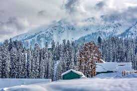
As the 40-day harsh winter period of Chilai Kalan started, Kashmir is likely to receive moderate to heavy snowfall ending the long dry spell.
The 40-day Chilai Kalan started with bone chilling cold. The Chilai Kalan beings on December 21 and ends on January 31 and chances of snowfall are very high during the Chilai Kalan.
The Met department has forecast a spell of wet weather on December 20-21, coinciding with the onset of ‘Chillai-Kalan’.
“Moderate to heavy snowfall is expected in the higher reaches of Kashmir especially in north Kashmir, while light to moderate snowfall may lash the plains,” the MeT official said.
The Valley has not witnessed any major wet spell so far this winter.
Kashmir is facing a severe dry spell, with no significant snowfall or rainfall recorded over the past two months, leading to the depletion of major water sources such as rivers, waterfalls, and springs.
According to meteorological data, the Kashmir Valley reported a significant rainfall deficit throughout December, a figure that underscores the gravity of the situation.
In the last two months, across Jammu and Kashmir, rainfall was deficient by over 33 per cent, with some districts hardest hit.
In Anantnag, Budgam, Bandipora, Baramulla, Ganderbal, Kulgam and Kupwara and Srinagar, the rainfall recorded from October 1 to December 17 this year was 62, 23.1, 27.5, 28.3, 37, 53.6, 57 mm and 38.6, which was deficient by 32 per cent, 64, 70, 71, 60, 61, 51 and 55 per cent, respectively.
The absence of anticipated snowfall is contributing to environmental concerns and affecting sectors such as winter tourism.
Experts have pointed to climate change as a major factor behind these erratic weather patterns, with unusually dry winters and irregular precipitation becoming more frequent.
El Nino, a climate phenomenon caused by abnormal warming of surface waters in the eastern Pacific Ocean, has altered weather patterns worldwide, including in Kashmir.
It usually brings higher temperatures and shifts in rainfall cycles, often leading to reduced precipitation and drier conditions in regions such as Southeast Asia during the December–February period.
Meanwhile, Pulwama in south Kashmir was the coldest place with the night temperature dropping to minus 3.2 degrees Celsius, according to the MeT office.
Srinagar recorded a low of minus 0.4 degree Celsius, about 2 degrees up from the previous night’s minus 2.1 degrees Celsius.
A thick layer of fog engulfed Srinagar and most other parts of the Valley on Saturday morning, especially near the water bodies.
In south Kashmir, Pahalgam recorded a low of minus 1 degree Celsius while Kokernag and Qazigund recorded 0.8 and minus 1 degree Celsius, respectively.
The night temperature in Kupwara settled at minus 0.7 degree Celsius.
In world famous ski resort of Gulmarg, the minimum temperature settled above the freezing point at 2 degrees Celsius.

© Copyright 2023 brighterkashmir.com All Rights Reserved. Quantum Technologies