
BREAKING NEWS
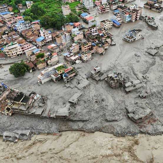
Srinagar, Aug 30: Catastrophic floods in Nepal have prompted Kashmiri geoscientist Prof. Irfan Rashid to examine satellite imagery of the disaster, offering fresh insights into the complex and growing hazards facing the Himalayan region.
Rashid, Head of the Department of Geoinformatics at the University of Kashmir, analysed imagery from USGS Earth Explorer, Planet and the European Space Agency’s Sentinel missions after images of the disaster emerged on social media.
Initial analysis was hampered by cloud cover and satellite-overpass timing. However, Landsat 9 imagery captured on August 26 provided a clearer view of the apparent failure zone.
Rashid, along with observations by geomorphologist Dan Shugar of the University of Calgary, identified what appeared to be a major ice collapse from the frontal section of a glacier, followed by rapid downstream movement of ice, rock, debris and water.
The source area is located at around 5,200 metres above sea level on a steep slope. Preliminary estimates suggest that 100–200 million cubic metres of ice, rock and debris may have been involved, although Rashid stressed that the estimate requires detailed scientific analysis.
“The larger scientific question is not only what triggered this particular event, but whether similar vulnerable locations can be identified elsewhere in the Himalayas,” Rashid said.
He cautioned that Nepal’s disaster should not be treated as a direct blueprint for Kashmir or Ladakh. However, it provides another important case for understanding how glacier instability, steep slopes, debris and water can combine to create catastrophic downstream impacts.
Rashid said satellite monitoring can help identify vulnerable locations before detailed ground-based assessments are undertaken, allowing authorities to shift from disaster response to risk prevention.
His concern is particularly relevant to Kashmir. A 2026 study by Rashid and colleagues mapped 155 glacial lakes in the Kashmir Himalaya and found that ice-contact proglacial lakes had expanded by 26 per cent between 1992 and 2024. Five lakes were identified as having very high susceptibility to Glacial Lake Outburst Floods (GLOFs), with potential risks to buildings, bridges, roads and hydropower infrastructure.
Other studies have also documented significant expansion of potentially dangerous glacial lakes and retreat of their feeding glaciers in the Jhelum and Warwan basins.
Rashid said the challenge is no longer simply generating scientific evidence but translating it into policy and action.
“It is fundamentally a science-policy-implementation gap,” he said, stressing the need to integrate hazard assessments into infrastructure and spatial planning.
He also advocated basic risk-reduction measures, including avoiding settlements and critical infrastructure in clearly vulnerable flood corridors.
The Nepal disaster, therefore, offers Kashmir a crucial lesson: the time to identify Himalayan risks is before the next catastrophe, not after it.
Srinagar, Aug 30: Catastrophic floods in Nepal have prompted Kashmiri geoscientist Prof. Irfan Rashid to examine satellite imagery of the disaster, offering fresh insights into the complex and growing hazards facing the Himalayan region.
Rashid, Head of the Department of Geoinformatics at the University of Kashmir, analysed imagery from USGS Earth Explorer, Planet and the European Space Agency’s Sentinel missions after images of the disaster emerged on social media.
Initial analysis was hampered by cloud cover and satellite-overpass timing. However, Landsat 9 imagery captured on August 26 provided a clearer view of the apparent failure zone.
Rashid, along with observations by geomorphologist Dan Shugar of the University of Calgary, identified what appeared to be a major ice collapse from the frontal section of a glacier, followed by rapid downstream movement of ice, rock, debris and water.
The source area is located at around 5,200 metres above sea level on a steep slope. Preliminary estimates suggest that 100–200 million cubic metres of ice, rock and debris may have been involved, although Rashid stressed that the estimate requires detailed scientific analysis.
“The larger scientific question is not only what triggered this particular event, but whether similar vulnerable locations can be identified elsewhere in the Himalayas,” Rashid said.
He cautioned that Nepal’s disaster should not be treated as a direct blueprint for Kashmir or Ladakh. However, it provides another important case for understanding how glacier instability, steep slopes, debris and water can combine to create catastrophic downstream impacts.
Rashid said satellite monitoring can help identify vulnerable locations before detailed ground-based assessments are undertaken, allowing authorities to shift from disaster response to risk prevention.
His concern is particularly relevant to Kashmir. A 2026 study by Rashid and colleagues mapped 155 glacial lakes in the Kashmir Himalaya and found that ice-contact proglacial lakes had expanded by 26 per cent between 1992 and 2024. Five lakes were identified as having very high susceptibility to Glacial Lake Outburst Floods (GLOFs), with potential risks to buildings, bridges, roads and hydropower infrastructure.
Other studies have also documented significant expansion of potentially dangerous glacial lakes and retreat of their feeding glaciers in the Jhelum and Warwan basins.
Rashid said the challenge is no longer simply generating scientific evidence but translating it into policy and action.
“It is fundamentally a science-policy-implementation gap,” he said, stressing the need to integrate hazard assessments into infrastructure and spatial planning.
He also advocated basic risk-reduction measures, including avoiding settlements and critical infrastructure in clearly vulnerable flood corridors.
The Nepal disaster, therefore, offers Kashmir a crucial lesson: the time to identify Himalayan risks is before the next catastrophe, not after it.

© Copyright 2023 brighterkashmir.com All Rights Reserved. Quantum Technologies