BREAKING NEWS
Water level will decrease after midnight: CE I&FC Deptt
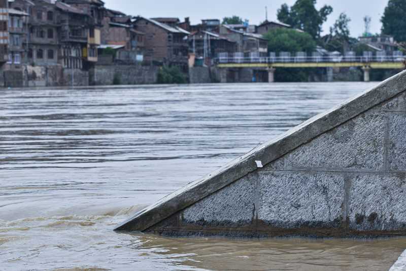
Kashmir remained on the edge on Monday as the water level in Jhelum kept on rising due to incessant rains.
The water level was at a touching distance of ‘alarm mark’ of 18-ft in south Kashmir’s Sangam gauge at 9 p.m.
"The water level in Sangam at 9 pm was recorded at 17.43 ft. As soon as it crosses 21-ft mark, a flood alert is declared," an official of Irrigation & Flood Control Department said.
At Ram Munshi Bagh in Srinagar, the water gauge reading at 9 pm was 15.35 ft against the alarm level of 18 ft and flood level of 21 feet.
“At Asham in North Kashmir’s Bandipora district, the Jhelum level was at 9.22 ft while in Wular the water level was 1577.18 m,” the official said.
The water level in Vishow Nallah at Khudwani at 9 pm was 7.66 m, 1.78 m in Rambiyara Nallah at Wachi while the nallah Lidder at Batkoot was at 0.46m.
“In Doodganga Nallah at Barzulla, the water level was 2.01 m at 9 pm while the reading at Sindh Nallah at Doerhama was recorded as 2.17 m,” the official said.
Several areas of Bemina, one of the worst hit areas of Srinagar during once in a century floods in 2014, submerged.
Reports said the water from the flood channel has seeped inside residential areas.
Chief Engineer I&FC Department Kashmir, Naresh Kumar said the current water levels except for a few areas remain within safe limits.
"As of now, there is no flood threat. The inputs from IMD suggest that the intensity of rainfall will decrease in the next 4-5 hours in the valley," he said.
Kumar, however, said that while there has been an upward trend in water levels in water bodies of the valley, they anticipate a receding trend by midnight.
"Our men and machinery will be on standby mode tonight to address any potential breaches in river embankments. Fortunately, there have been no reports of any embankment breaches so far," he said.
The administration has urged residents, particularly those living near the Jhelum River and its tributaries, to exercise caution and avoid venturing close to water bodies. Tourists, boatmen, and those using traditional river crossing points in Dal Lake and Jhelum River are asked to verify water levels before attempting to cross.
In view of the flood threat, DC Srinagar has directed officers to remain in the state of readiness by mobilising men and machinery on ground particularly at vulnerable spots to avoid any loss to human lives or property damages.
The DC laid emphasis on round the clock monitoring of vulnerable flood prone areas and ensuring timely dissemination of information among the people viz. flood alerts, evacuation points/centres, transportation plans, etc., so that people are updated about the evacuation/rescue plans well in time.
He directed the concerned officers to focus on the identified vulnerable spots so that rapid action is ensured in case of need or to arrest embankment breach, if any.
Water level will decrease after midnight: CE I&FC Deptt
Kashmir remained on the edge on Monday as the water level in Jhelum kept on rising due to incessant rains.
The water level was at a touching distance of ‘alarm mark’ of 18-ft in south Kashmir’s Sangam gauge at 9 p.m.
"The water level in Sangam at 9 pm was recorded at 17.43 ft. As soon as it crosses 21-ft mark, a flood alert is declared," an official of Irrigation & Flood Control Department said.
At Ram Munshi Bagh in Srinagar, the water gauge reading at 9 pm was 15.35 ft against the alarm level of 18 ft and flood level of 21 feet.
“At Asham in North Kashmir’s Bandipora district, the Jhelum level was at 9.22 ft while in Wular the water level was 1577.18 m,” the official said.
The water level in Vishow Nallah at Khudwani at 9 pm was 7.66 m, 1.78 m in Rambiyara Nallah at Wachi while the nallah Lidder at Batkoot was at 0.46m.
“In Doodganga Nallah at Barzulla, the water level was 2.01 m at 9 pm while the reading at Sindh Nallah at Doerhama was recorded as 2.17 m,” the official said.
Several areas of Bemina, one of the worst hit areas of Srinagar during once in a century floods in 2014, submerged.
Reports said the water from the flood channel has seeped inside residential areas.
Chief Engineer I&FC Department Kashmir, Naresh Kumar said the current water levels except for a few areas remain within safe limits.
"As of now, there is no flood threat. The inputs from IMD suggest that the intensity of rainfall will decrease in the next 4-5 hours in the valley," he said.
Kumar, however, said that while there has been an upward trend in water levels in water bodies of the valley, they anticipate a receding trend by midnight.
"Our men and machinery will be on standby mode tonight to address any potential breaches in river embankments. Fortunately, there have been no reports of any embankment breaches so far," he said.
The administration has urged residents, particularly those living near the Jhelum River and its tributaries, to exercise caution and avoid venturing close to water bodies. Tourists, boatmen, and those using traditional river crossing points in Dal Lake and Jhelum River are asked to verify water levels before attempting to cross.
In view of the flood threat, DC Srinagar has directed officers to remain in the state of readiness by mobilising men and machinery on ground particularly at vulnerable spots to avoid any loss to human lives or property damages.
The DC laid emphasis on round the clock monitoring of vulnerable flood prone areas and ensuring timely dissemination of information among the people viz. flood alerts, evacuation points/centres, transportation plans, etc., so that people are updated about the evacuation/rescue plans well in time.
He directed the concerned officers to focus on the identified vulnerable spots so that rapid action is ensured in case of need or to arrest embankment breach, if any.

© Copyright 2023 brighterkashmir.com All Rights Reserved. Quantum Technologies