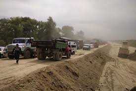
In 1971-1991 master plan present by bye pass road was envisaged to keep the through traffic of trucks, frequent movement of defense vehicles away from core city congestion and provide comforts of mobility to the general public. Over the last forty years the corridor has come up in phases with frequent road humps in the form flyovers and bridges on fast moving corridor severely impeding and disrupting mobility causing significant increase in travel time, driver discomfort, and negative environmental impact with frequent fatal accidents and decreasing efficiency. It has made the corridor unsuitable for high speed arterial traffic and transmuted it into a local urban road suited to urban traffic environment. At present bypass road stands as a testimonial example of how grade-separated structures when poorly integrated with horizontal and vertical alignment, can transform a relief road into a malady with great socio-economic ramifications. Five flyovers and four bridges that are part of this infrastructure have instead become nine successive torture points for millions of passengers and drivers every year. This corridor of 14.5 km stretch continues to exact a heavy price in terms of human lives, spinal health, vehicle maintenance, and lost productivity. The road gives a feel of a roller-coaster travel, designed by someone who hates both drivers and physics. The road being developed in valley floor, partly on raised land from the surrounding low-lying areas where humps need not to have been unescapable quirks of mountain topography but seem to have been adopted as correctable engineering failures with no validation for excuse of terrain constraint. A bypass is supposed to bypass congestion and stress, in our case, it has become the primary source of both. The road is still in the process of development early 1980’s till 2025 as some parts including grade separators service lanes and side infra is still in the process of development.
Basically, it was conceived as the lifeline that would decongest the historic city and relieve it from acute traffic problems by keep heavy commercial traffic away from Panthchowk-Lal Chowk–Jahangir Chowk-Batamaloo corridors, forming the central spine and provide a smooth, high-speed alternative route along the western and southern periphery of Srinagar. Conceivably, it is an impressive piece of infrastructure with four-lane divided carriageway now for of its whole length, median width varying from 1.5 m to 4.5 m, service roads in certain stretches, and five grade separators, four major bridges to negotiate railway crossings, flood spill channels, river Jhelum, and intersecting arterial roads. In reality, this very bypass has become one of the most uncomfortable, fatiguing, and statistically dangerous stretches of National Highway in the Kashmir Valley, primarily because of the eight massive “humps” created at the intersections by the approaches to these flyovers and bridges. What should have been a 10–12 minute free-flow run at 80 km/h has turned into a 20–45 minute ordeal of repeated braking, suspension abuse, spinal stress, and high accident risk, especially after dark. The road is turning into a death trap due to increased accident occurring on the stretch of road. Apart from the infamous accident of Tengpora, recently a number of accident have been reported on this road near Sanatnagar, Nowgam, Hyderpora and other patches taking heavy toll of human life. Thus, making Srinagar Bypass road, particularly the Parimpora -Pantha Chowk stretch as an accident-prone corridor with a growing number of incidents, including taking ones also. Reportedly about more than 40% of the accidents in Srinagar are recorded to be occurring on this specific bypass stretch.
Bye Pass’s Hump Anatomy
The bypass crosses and runs the elevated structures, each producing a pronounced hump because of inadequate transition length and excessive ramp gradients including Bemina crossing flyover, Tengpora bridge over flood channel ,Pantha Chowk flyover (NH-44 junction), ,Channapora bridge over Doodhganga, Panatha Chowk bridge over River Jhelum, Hyderpora Crossing flyover, Nowgam crossing Flyover, Bridge near British school and the very recent addition to this list Sanatnagar crossing flyover also falls in the same category. Studies have revealed that most of the daily commuters reveal that the vertical crest curves on the approaches to these structures violate IRC:73-1980 and IRC SP:23-1993 recommendations. Most of these humps have typical fault of high approach gradients of 4–6 % (against recommended maximum 3–3.5 % for 80 km/h design speed) , depressingly transition lengths for vertical curves, as low as 40–60 m where minimum 120–150 m is required for comfort and safety at 80 km/h, sharp and sudden change of grade (algebraic difference of grade, A) reaching 6–8 %, producing K-values of only 10–15 against the desirable 30–40, and inadequate sight distance over the crest and downslope ramps which turns to be very dangerous at night when headlights are blinded by the upward slope extreme weather conditions. The result is that every vehicle, whether a passenger car, a loaded 407 mini-truck, or a Srinagar–Jammu 40-ft trailer, has to slow down from 80 km/h to 30–40 km/h before climbing the hump and then accelerate again on the descent. A simple back-of-the-envelope calculation shows that a vehicle loses and regains approximately 25–30 m of elevation eight times in 14.5 km, translating into roughly 200 meters of cumulative vertical travel. This is equivalent to climbing and descending a 60-storey building while supposedly travelling on a “bypass” meant for uninterrupted flow. High speed variance is directly correlated with rear-end and sideswipe collisions, and the J&K Traffic Police accident data for 2019–2024 confirms that 64 % of crashes on the bypass occur within 200 m of these flyover approaches.
Technical Standpoint
From a pure traffic engineering standpoint, the design defeats the very purpose of a bypass. The fundamental objective of any ring road or bypass is to provide higher operating speed and lower travel time variability than the urban through-route. Yet independent GPS-based travel time surveys conducted by the Department of Transport Planning, NIT Srinagar (2023) reveal that an average running speed on the bypass during off-peak hours, 38–42 km/h ,average running speed through the city (MA Road–Residency Road–Batamaloo route) 32–36 km/h. Journey time reliability (85th percentile vs 50th percentile): worse on bypass because of forced speed cycles at humps. In other words, the bypass offers only marginal time savings while imposing significantly higher physical and psychological stress on drivers and passengers.
Safety Requirements
The combination of sudden deceleration, loss of tyre-road contact on the crest (especially for two-wheelers and lightly laden pickups), and blinding of following drivers by the high-mounted headlights of vehicles climbing the opposite slope creates deadly black spots. Night-time KSI (Killed or Seriously Injured) rates on the bypass are 2.7 times higher than on the old city route despite lower traffic volumes after 20:00 hrs. Common crash types and Rear-end collisions are becoming a normal happening due failing of trailing vehicles to notice rapid deceleration of lead vehicle approaching the hump. Loss-of-control crashes of two-wheelers due to airborne front wheel on crest is also reported by the general public. Head-on or sideswipe incidents caused by drivers drifting into the opposite lane while trying to maneuvering curves and potholes that invariably develop and exist on the steep gradients is also a cause worry on this road. The problems are more aggravated in the absence of rumble strips, advance warning signs with flashers, and proper reflective delineation on the crests. Most humps are not even provided insignia of mandatory chevron boards or edge line reflectors recommended by IRC:35-2015.This road is also suffering from repeated shock loading on the steep gradients accelerates pavement distress. Rutting and shoving are visible on every approach within 2–3 years of resurfacing. A study by the Central Road Research Institute (CRRI) team that visited in 2021 estimated that vehicle operating costs (fuel tyre wear suspension maintenance) on the bypass are 18–22 % higher per kilometre than on a flat alignment of similar category, nullifying any fuel savings expected from a bypass.
Passenger discomfort is not merely anecdotal. Measurements using smartphone accelerometers (ISO 2631-1 standard for whole-body vibration) consistently show peak vertical acceleration values crossing 0.8–1.2 m/s² on the crests, placing the ride in the “extremely uncomfortable” category for periods of 15–20 minutes, the exact duration of a bypass trip. Professional drivers (taxi operators on Srinagar–Jammu route) report chronic lower back pain directly attributable to the seven humps. A survey of 250 regular users conducted by the Sher-e-Kashmir Institute of Medical Sciences (SKIMS) Orthopaedic Department in 2024 found that 71 % complained of increased lumbar pain after switching to the bypass route, with 18 % seeking medical consultation for disc-related issues. Fatigue indices measured through heart-rate variability are also significantly higher because of the constant cycle of braking-accelerating-braking instead of steady-speed cruising. These measures, costing approximately ₹60–80 crore in total, would still keep the average speed lower than originally envisaged but would drastically reduce speed differential and crash risk.
Exploring Possible Solutions
Roads like present bye pass are developed for generations and these have to function and serve the public infinitely in the forerunner of the future. Generally, levelled bypass as true high speed corridors, are preferred as these provide speed consistency, alignment continuity, safety, and function as successful high speed arteries. In our case, Srinagar city bye pass is interspersed with frequent humps caused by flyovers and bridges. These humps disrupt speed consistency, increase braking, acceleration cycles, raise fatal accident risk, fuel consumption and driver fatigue. These aspects are defeating the very purpose of the bye pass to ensure smooth uninterrupted traffic flow and reduce the traffic congestion on city radials. This vital road artery should have been used sparingly and strategically in a manner to avoid conversion of road into a sequence of vertical obstacles. In additional, series of fatal accident which took place over last few years has been the most agonizing aspect of this road. These accidents are often attributed to rash driving, and drunken driving, however, underlying factors humps as vertical obstacles, poor design, missing road infra and traffic management seem to have not caught the eye and properly noticed. Therefore, there is an urgent need to ensure that all design nitty gritties are respected and adhered for the safe and speedy movement on the corridor. For correcting the vertical alignment and the underlying fallacies in design it would not be prudent to completely relay the existing infra but a thought retrofitting is needed for all most all the structures a horizontal and vertical alignments after a thorough and detailed analysis establishing the appalling critical areas. The retrofit measures need to focus on improving safety and comfort including re-profiling of approach ramps by milling and overlaying longer transition curves, installation of pre-warning rumble strips 150 m and 80 m before each hump with solar blinkers, raised reflective pavement markers (cat-eyes) every 3 m on the crest curve and chevron alignment markers ,speed calming tables (flat-top humps) 100 m before each climb to enforce uniform 50 km/h approach speed instead of chaotic 30–90 km/h variation, high-mast lighting focused on the crest and descent zones ,variable message signs displaying “Hump Ahead – Reduce Speed” triggered by radar, strict enforcement of speed limits (50 km/h) in hump zones using interceptor vehicles and automated cameras. In additional, automated traffic signals need to be made functional to streamline the mobility. In addition, outer ring road of the Srinagar city which also form almost the valley rim road is under process of development such mistakes necessarily need to be avoided in its development to increase its efficacy and fulfilling the purposes for which it has been conceived and developed. All this is pertinently needed to safeguard the human life, economy, and sustainability because roads act as the transit lines for these vital aspects of modern life.
Email:-----------hamwani24@gmail.com